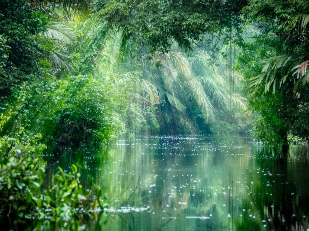
Driving through fields of cotton, potatoes, wheat, corn and pumpkin, we cross the Tigris; a river of huge historical significance but whose modern-day stature has been dammed and contained to be little more than an irrigation canal. I had entered Mesopotamia. The land between two rivers. The land between the Tigris and the Euphrates. The fertile crescent, the cradle of civilisation.
We stop in Dara (Anastasiopolis), a dusty Kurdish village close to the Syrian border. The home to a former Roman city that was garrisoned by the Emperor Anastasius in AD 507 as a defensive outpost on the borders of the Persian Empire, with a population presumed to be about 60,000 before the Persians overran the town a century later. Over the centuries, it was laid siege to a number of times before being largely destroyed in the 13th century.
The ruins lie scattered around the village, with many of the original stones having been reclaimed into the houses of the villagers. Yet there is enough still standing – huge stone gates and stone irrigation canals – to appreciate why Dara is thought to be the spot where Mesopotamia’s first dam and irrigation canals were constructed.

In trying to visualise the scale of the city, I was intrigued enough to enter a modest doorway and gingerly negotiate fifty steps down into the murky darkness of the city’s underground cistern. Reaching the bottom, I stared upwards in awe. This was no underground cistern but an underground cathedral with twenty-metre arches that soared above me.
Another impressive feature of Dara is the rock-cut tombs carved directly into the bedrock. The hills at the eastern edge of the town were originally used as a source of stone but the flat facades left by cutting were later converted into a necropolis. Whilst I was impressed by the number of Turkish tourists visiting and taking huge interest in the site, I was surprised by the lack of ticket office and entrance fee. Elsewhere in the world such a site would be a celebrity, in Eastern Turkey it is a postscript among the mind-blowing wealth of antiquities.
Other ‘footnotes’ include Deyrul Zafaran, literally Monastery of Saffron, and Mardin, known as ‘the White City’ because of its distinctive pale limestone buildings. Mardin, the Amharic word for castle, was first fortified in the 4th century as an eastern outpost of the Roman Empire, before coming under Muslim rule in AD 640. The town’s commanding location at the point where the old caravan route from the Mesopotamian plain reaches the edge of the highland plateau of Anatolia accounts for its complex history and why it was known as the city of languages – Jewish, Kurdish, Assyrian and Arabic all being spoken here.
The city of Diyarbarkir takes its present name from the Arab tribe, the Beni Bakr, who took the city in AD 639, Diyarbakır meaning ‘Place of the Bakr’. The great Old City is enclosed within five and a half kilometre black basalt walls that date back to AD 297 when the city was taken from the Persian Sassanids and annexed to the Roman Empire. Successive Byzantine, Arab, Kurdish and Turkish dynasties have renovated and strengthened them. In their present form, however, they are the work of the Seljuk Malik Shah who rebuilt them completely when he took the city in 1088.
The size of black basalt city wall – ten metres high and up to five meters wide – that stands more or less intact for five and half kilometres gives you some sort of feel for the extent and power of the city. Positioned at the limit of navigability on the Tigris, Diyarbakır dominates the expanse of the northern Mesopotamian Plain.
Walking on the ramparts, overlooking the plateau far below, I get a sense of the sway of the dominion but it was inside the Mardin Gate that I shivered at the imagined history. The gate was three channels of a series of five-metre high arches and columns – the noise as you rode into town on horseback must have reverberated around the cool dark walls to deafening effect.
Within the city walls I visit an Armenian church, a Chaldean church and several mosques within quick succession. Diyarbakır has more historical mosques, churches and other notable buildings than any other Turkish city, except İstanbul. It is little wonder that it is a UNESCO World Heritage Site.
Given the city’s history and successive conquerors there is a consistency in the buildings with many being built with alternating stones of black basalt and pale limestone. Some are more blatant and have simply adapted what was there before. The Great Mosque, Ulu Cami, has an impressive courtyard that once would have formed the basilica of the cathedral of St Thomas, the mosque’s predecessor.
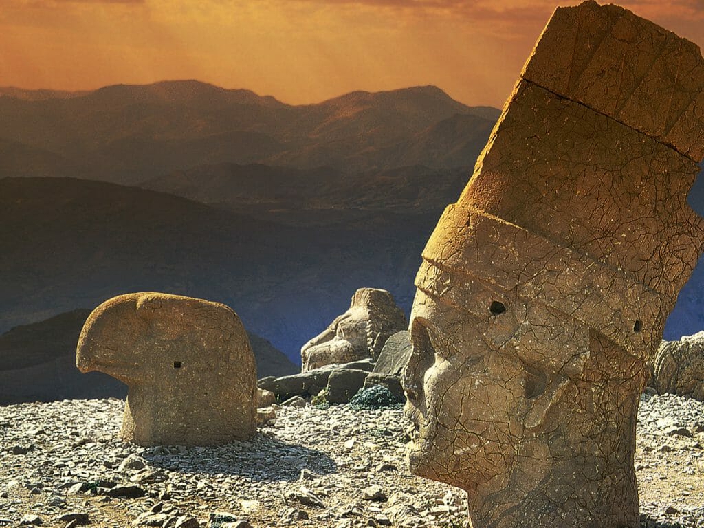
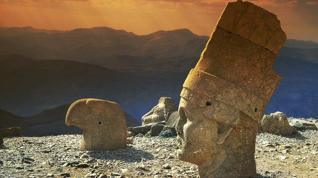
Looking out over my first view of the Euphrates, I savoured the sweetest pomegranate juice that had been freshly squeezed for me by a smiley local farmer. I would need the energy to get me to the 2,206 summit of Nemrut Dagi (Mt Nemrut), named after Nimrod, Noah’s son. Here Antiochus, an insignificant local Commagene ruler, described by his neighbours as a “petty princeling”, had delusions of grandeur in his burial monument. Antiochus had the temerity to seat himself – the bodies of five stone statues that are eight to nine metres high are depicted in sitting positions – amongst the divine figures of Apollo, a Commagene fertility goddess, Zeus and Hercules.
The heads of the statues, long since toppled to the ground by the ravages of time, were smaller than I had imagined, yet still an impressive two to three and half meters high. Their unseeing stone eyes staring blankly out over the dramatic vista below. It is the majesty of the setting, remote and inaccessible, which gives this bizarre burial monument a surreal feel. Whilst there is something ludicrous about the ego-inflated king’s choice of final resting place, its isolation and unexpectedness draws the crowds.
We descend through a stunning riverine gorge as great slabs of grey limestone bubble and protrude from the yellow earth at awkward angles. We cross a high-arched bridge built by Septimus Severus in the 2nd century AD over the Cendere River, a tributary of the Euphrates. Until 2005 vehicle traffic used to cross this bridge – testament to Roman engineers of the past. The landscape softens and enter a steppe environment of which much is under cultivation, tobacco, pomegranate, pistachio and almonds some of the many crops.
The road turns the corner and we catch our first glimpse of Sanilurfa, a modern metropolis of high rise buildings that has exploded over the last twenty years to accommodate a population of two million. “Every time I come here, I see new buildings,” remarks Sabahattin.
Muhammed is a fourteen year old Kurdish boy who cleans shoes at one of the local hotels in Sanilurfa, in the mornings. In the afternoon he goes to school. He is originally from Kobani, in northern Syria – the border is 45 kilometres away – but fled with his family in late 2014 when the town was under siege from ISIS.
Turkey is sensitive to its Kurdish population of 25 million. There are a further seven million Kurds in northeast Iran and also across the border in northern Syria. The Kurds are the largest minority in the world without a state. No Kurdish is taught at school in Turkey and twenty years ago Kurdish music was forbidden. Turkey shares a 900 kilometre border with Syria and a 400 kilometre border with Iran. Both borders are ‘protected’ in their entirety by a large concrete wall and barbed wire.
Muhammed was one of the ‘lucky’ ones to make it out of Syria and has since spent half of his life in a country which grants him little status. Undaunted, his irrepressible smile and cheeky charm make him instantly likeable. His eagerness to learn and please win him many friends.
Inspired by Muhammed’s enthusiasm for life, I head out to explore Sanliurfa, or rather Urfa, as it is known locally. I rub shoulders with families out for a late afternoon stroll around the carp pools that legend links with Abraham. Parents try to persuade excited children to stand still for a family selfie. The cave revered as the fabled birthplace of Abraham smells of stale feet, the pious sip the fountain’s waters seeking cure. I stroll through the Deragh complex of mosques, the moon a backdrop to the minaret as birds begin to roost. The sun setting, I dive into the tight-packed bazaar and quickly seek refuge in Gumruk Han, a caravanserai, where I sipped the most mouth-watering cup of pistachio coffee.
The next morning, the light wind rustling the yellowed grass sprouting from limestone rocks, rows of olive trees lining the hillside and with the chirping of birds serenading us, we climb the mound of Gobekli Tepe, the highest point on the limestone plateau. The Turkish words means pot-bellied hill – not a marketeer’s first choice of name for one of the most important sites in history.
Perhaps the choice of name and its recent discovery – unearthed by a farmer in the late 1980s, excavations only began under the supervision of German archaeologist Dr Herman Schmidt in 1994 – explain why so few visit this site, as yet. Some three million, the vast majority of whom are Turkish, as opposed to at least ten times that number that will visit the sites of western Turkey.
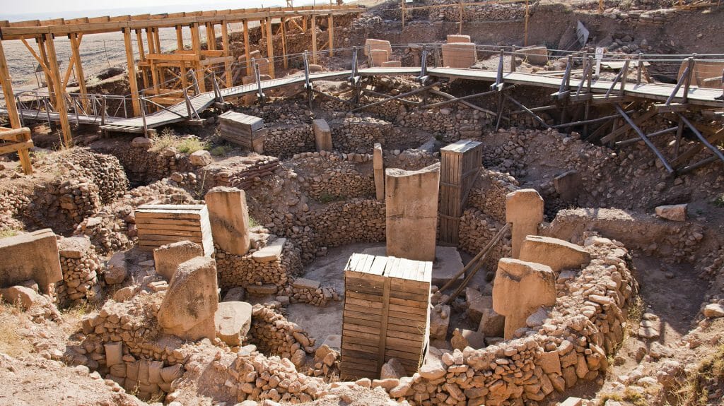
Four separate stone circles have been excavated, each with a diameter of at least twenty metres and containing four-metre high T-shaped limestone pillars, smoothed and carved with animal figures. These are the earliest carvings on stone; an intriguing zoo of foxes, ducks, lions, boars, snakes, bull, vulture head, scorpion and crane are all featured.
Gobekli Tepe has changed history. Not because it predates Stonehenge by 6,000 years but that previous thinking had thought man to be nomadic at this time. We were unappreciative that he was living a more settled existence and certainly not with temples, let alone of this stature. Or size – it is staggering that only 10% of the site has been excavated.
To try to better understand what we had seen and why it is one of the most startling monuments on the planet, we headed back to Sanilurfa and its extraordinary museum. An educational and revelatory experience in time travel, the various exhibition halls took me effortlessly from Palaeolithic times of 1.1 million years ago to 10,500 BC and the Neolithic. Here I saw a recreation of Gobekli Tepe giving a sense of the scale and height of the pedestals.
It was not all about Gobekli Tepe. There were displays and stone carvings from the contemporary Karahan Tepe with its carved stone human figures. Perhaps most intriguing of all was the 11,000 year old Urfu statue, the oldest known life-size human sculpture in the world to have survived intact. With a V-shaped necklace, hands clasped together at his waist and almost robotic head, the statue stared out of his black obsidian eyes.
Five thousand years later in 5,500 BC we come across the arrival of Chalcolithic pottery, of clay bird whistles. In 3,200 BC we discover the Bronze Age. In 1,200 BC the Iron age arrived and Assyrian tiny writing of part of the epic poem ‘Lamentation to Gilgamesh’. And then in 330 BC we entered the Hellenic period and that fusion of east and west.
Next door to the archaeological museum is the Amazon Mosaic Museum given birth by the remarkable discovery in 2006 when a bulldozer clearing the ground for a new theme park hit upon some mosaics. Two years of careful excavations brought to life an opulent 12-room villa, thought to belong to a senior official of the Roman Byzantine Empire.
Whilst experts have called them the world’s most valuable mosaics due to their unique subject matter and their excellent workmanship, I was struck by the unusual: an Amazon warrior queen, one breast bare to allow for better fighting; a reluctant zebra being led on a halter.
I thought that I had had my fill of museums but I was not accounting for the Zeugma Mosaic Museum in Gaziantep, 140 kilometres west of Sanilurfa.
Seleucus was one of Alexander the Great’s generals that rose in the division of Alexander’s empire to become total ruler of Asia Minor and Mesopotamia, founding the eponymous Seluccid Empire. Key to Seleucus’s empire was the Euphrates, the birth of civilisation and barrier between east and west, and Seleucus founded a city on both banks of the river linked by a stone bridge. Zeugma means bridge.
With a population of 80,000, Zeugma was the largest city in the Eastern empire, covering some 20,000 acres housing impressive villas decorated with statues and mosaics. Zeugma was of huge strategic importance and was a centre of wealth until 256 AD when Rome lost control of the region and the city was plundered and burnt down.
Zeugma’s legacy is now confined to the museum. The expression of fury encapsulated in a statue of Mars indicative of its craftsmanship. The exquisite lines of subtle frescoes a glimpse at its artistry. The dazzling beauty of a wealth of mosaics tribute to its glory.
The jewel in the crown of the museum is the ‘Portrait of the gypsy girl’, the mosaic Mona Lisa. Whilst I was captivated by her gaze, that does follow you around the room, I was flabbergasted at the optical effects of some of the other mosaics. In an Achilles mosaic, the figures are leaning to the right but the columns in the background are straight, creating the impression of movement. In others, the geometrical patterns create the illusion of dimension. Even without the aid of water – many of the mosaics would have been the bottom of shallow pools – many of the images danced entrancingly.
“There are more, better mosaics in Antioch,” Sabahattin remarked matter-of-factly. I have to come back.